What is XPStorm?
XPStorm is for dynamic urban stormwater and river systems modeling. It gives you confidence in your model to clearly convey results to engineers, planners, and the general public.
XPStorm is for dynamic urban stormwater and river systems modeling. It gives you confidence in your model to clearly convey results to engineers, planners, and the general public.

Meeting the requirements in the U.S. for NFIP submissions, XPStorm is the solution chosen by hundreds of engineers, scientists, and modelers worldwide.

XPStorm takes 1D and 2D modeling and allows you to use it for stormwater and river conveyance sizing, site development, and medium-to-large flood studies, river modeling, and watershed studies.

Easily convey output results to assess your options. Clearly communicate results to all stakeholders and empower better decision-making.

Combine hydrology and hydraulics in the same model to save valuable time. Complete stormwater and watershed Master Plans to confidently manage capital planning and mitigate flood risks.
Run floodplain simulations for complete urban environments in a fraction of the time compared to competing, specialized tools. Generate flood and hazard maps, emergency evacuation plans, capital improvement plans, flood risk identification and river restoration modeling.
Conduct extensive “What if” scenario simulations to plan for intense storm events and develop action plans for emergency preparedness. Our software contains tools to assist emergency personnel in identifying important evacuation routes.
XPStorm’s Scenario Manager lets you run multiple simulations in parallel – while keeping track of all changes. Conduct comparative analysis of storm events or system expansions as well as evaluate the performance of green infrastructure.
Jump start your model by importing GIS, CAD, HEC-RAS data and more so that you can construct models from various data sources in a single repository. XPStorm’s graphical environment allows the modeler to create and modify the network interactively on the screen using just a mouse and graphic tools.
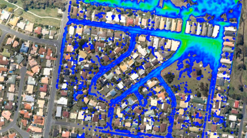
Take the simulation results back to your production environments – tailored to meet your specific applications. Color coded maps display time series such as water depth and elevation. Scaled vectors can display flow or velocity. All 2D maps can be exported to GIS or CSV data files.
Learn how technology helps ensure the impacts of urbanization and extreme weather do not put our environment or communities at risk
Learn how Jacobs Engineering created a Groundwater Infiltration Model (GIM) in InfoWorks ICM to calibrate the wet weather flows in Dekalb County’s collection system model.
Scottish Canals created a digital twin of the North Glasgow water network to build Europe’s first Smart Canal.